SOTA Activation: Ben Loyal, GM/NS-052
2 March 2011
River MacLeod, MM0HAI

Ben Loyal is one of the most northerly hills in Scotland. It's a Corbett at 2506ft and lies East of Ben Hope, the most northerly Munro. Wikipedia claims Loyal means level, which the hill appears to be except for its peaks. The central and highest peak, An Caisteal, qualifies for SOTA. This we decided to climb.
We approached from the North, passing the East side of the first peak. The path was poor and for the final section of climbing we just headed off up in the expected direction of the summit. We couldn't see the summit because of mist but after a while I saw some patches of snow and then rock shining through. It tuned out we were in the right place; then the peak loomed.
The summit is a large slab. Initially it looked like there would be a climb of moderate length over this. Although not at all steep this concerned me because the rock was wet and exposed. It would be easy to be blown over the edge. It turned out that further round there was only a short climb to the summit.
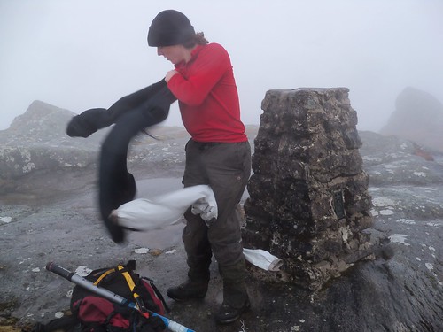
The wind would have made it difficult to erect an HF antenna. It was also cold and unpleasant and I don't think father would have tolerated the time taken for an HF activation. I almost did not activate the summit at all but decided to try with the handie at least. There was quite a force on the aerial so I held that as well as the radio to save the connector. I think the upper sections of the telescopic aerial bent slightly.
I was not really expecting anything on VHF because the hill is so remote but despite this two contacts were made. On 2m I spoke to stations in Stornoway and Elgin. The first was made sitting a few meters from the trig point and the second with radio above trig and log paper on it. I posted a spot by SMS but there was no response - I probably did not wait long enough - it was too cold to hang around. Operating zips to put the radio away was difficult. I think some very thin and tight gloves would be useful.
Descent was by closely retracing the ascent route, using boulders as memorised waypoints, until off the peak. There were no cliffs after this so it was simply a matter of pointing downhill until out of the mist.
At least carrying unused lumps of lead and other metal up hills should be good for fitness.